

More than 2,000 years ago, trade between Roman Aquileia (in the area of present-day Venice) and Pannonia with the coast of the Baltic Sea, centered around the highly valued amber, was developing dynamically. The greatest volume of this exchange is believed to have taken place in the 3rd century CE, although the first expeditions may have occurred as early as the 5th century BCE. However, it is impossible to clearly determine what the Amber Road actually looked like, so we take a closer look at the latest German studies that point to the significant role of Kuyavia and Bydgoszcz.
Over the years, various theories have emerged, but it must also be acknowledged that science has evolved. Today we are able to examine the past much more precisely than technology allowed 50–60 years ago. One of the most recent studies is a 2011 publication by an interdisciplinary research team from the Technical University of Berlin, which can be rendered in Polish as Germania magna – a new look at an old map.
The study refers to the map created by the Greek Claudius Ptolemy, discovered in Alexandria and dated to the 2nd century CE. With the tools available at the time, the Greek scholar attempted to map Europe as it was then known. The problem with this map is that it was impossible at the time to produce maps as accurate as those of today, which is why researchers attempt to translate it into a modern coordinate system. German scientists undertook this work more than a decade ago, using expert methods and advanced mathematics.
“The towns of Arsonium, Calisia, Setidava, and Ascaucalis (from south to north) lie, according to the corrected coordinates, within the main area of Roman imports. Calisia is commonly identified with today’s Kalisz (Greater Poland Voivodeship) based on linguistic studies. The course of this route is clearly visible especially on the basis of finds of terra sigillata from Central Gaul and Rheinzabern,” we read in the study (author’s own translation from German). “With regard to the ‘Amber Road,’ it can be stated that Kuyavia played a central role, at least in the field of local amber processing. This is evidenced by numerous semi-subterranean huts containing raw material, production waste, semi-finished products, and finished goods. However, these cannot serve as proof of intensive trade with the south.”
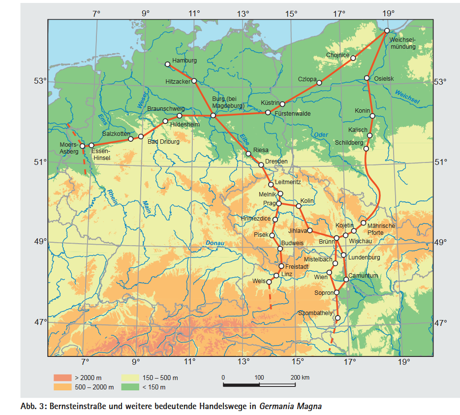
A key role is therefore played by the center of Ascaucalis (also referred to as Osielsk), which researchers, using expert methods and advanced mathematics, identified with Bydgoszcz. This is also reflected in the diagrams of the route included in the scientific publication.
Sectetur adipiscing elit. Sed nisi ipsum, aliquet ac vulputate eu, congue nec diam. Mauris ligula metus, tempus eget scelerisque nec, aliquet et risus. Nulla consequat elit vel ipsum pharetra quis tempor metus varius.


")


